Aerial(UAV) Drone Survey
Professional Aerial UAV Drone Survey Services in Chennai, India
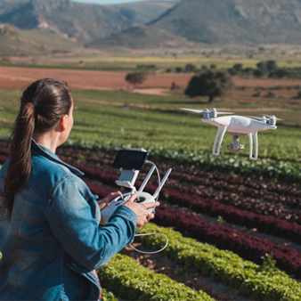
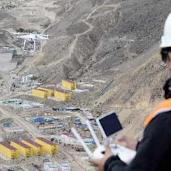
At MAPe IT Solutions, we provide comprehensive aerial UAV drone survey services across India and internationally. Our team of experienced engineers, licensed drone pilots, GIS experts, and software developers delivers end-to-end drone solutions from data capture through to processing, analysis, and integration with online and mobile platforms. Drone and UAV technologies have fundamentally transformed the way industries collect geospatial data. Faster, safer, and more cost-effective than traditional survey methods, drone surveys deliver high-resolution aerial imagery, precise 3D models, and accurate terrain data for a wide range of applications from large-scale infrastructure mapping to detailed site inspections. With a fleet of multi-rotor and fixed-wing UAVs equipped with high-zoom cameras, thermal cameras, NIR sensors, and multispectral sensors, MAPe IT Solutions is one of India's leading drone survey companies. Our nationwide network of certified drone pilots ensures quick team mobilisation and fast project delivery anywhere in India.
Leading Drone Survey Company in India
MAPe IT Solutions operates across all major states in India and also provides drone data processing outsourcing services to international clients in the USA, UK, Middle East, Australia, and beyond. Our web-based drone data management platform enables clients to host, view, share, and collaborate over drone data — including orthophotos, contours, DEMs, and drone videos — supporting infrastructure planning, project progress monitoring, and critical asset management.
Our clients trust us for:
Our Aerial UAV Drone Survey Solutions
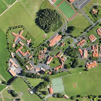
Geo-Referenced Ortho-Mosaics
We produce high-resolution, geo-referenced orthomosaics from drone imagery, providing accurate aerial base maps suitable for engineering design, land use planning, and GIS analysis. Every pixel is precisely positioned in a real-world coordinate system, making our orthomosaics ready for direct use as mapping layers.
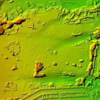
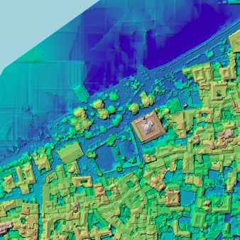
Digital Elevation Model (DEM), Digital Surface Model (DSM) & Digital Terrain Model (DTM)
Our drone surveys generate highly accurate elevation models that capture the three-dimensional shape of the terrain and surface features. These models are essential for earthwork calculations, flood analysis, drainage design, and infrastructure planning.
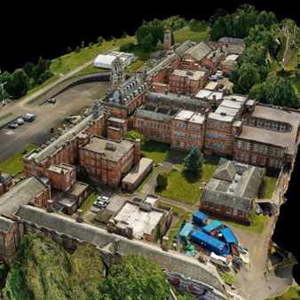
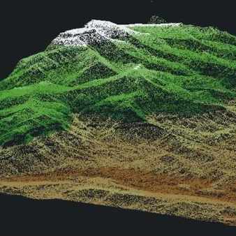
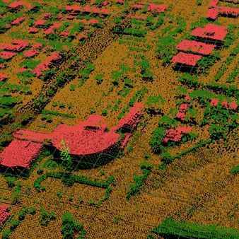
3D Modeling, Point Cloud Generation & 3D Mesh
Using photogrammetric processing of drone imagery, we generate dense point clouds, 3D meshes, and realistic 3D models of terrain, buildings, structures, and assets. These outputs are widely used in construction, heritage documentation, infrastructure inspection, and urban planning.
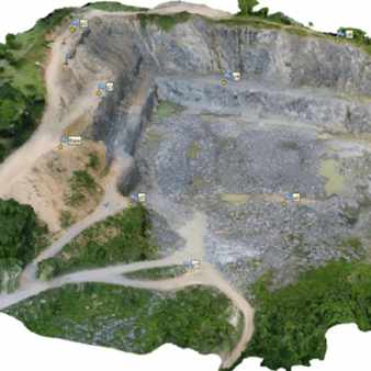
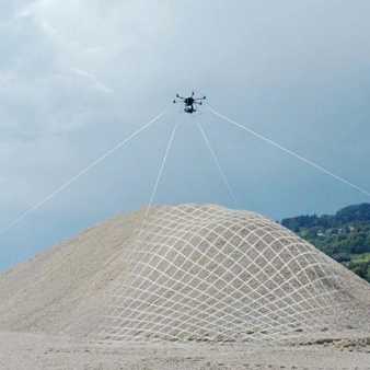
Contour Line Generation & Volumetric Calculations
We generate precise contour maps and perform accurate volumetric calculations from drone-derived terrain models. These services are critical for mining, quarrying, construction, and earthworks projects where material quantities need to be monitored and reported.
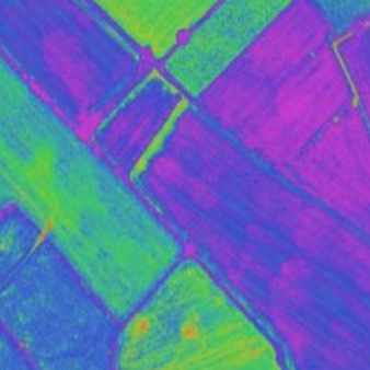
Multispectral Photogrammetric Applications & Agriculture / Forestry
Our drones equipped with multispectral and NIR sensors deliver powerful insights for agriculture, forestry, and environmental monitoring. We generate crop health indices, vegetation maps, and canopy analysis reports that help farmers, foresters, and environmental managers make data-driven decisions.
Thermal Drone Inspection
Our thermal camera-equipped drones provide non-contact, non-destructive inspection of infrastructure, industrial assets, and buildings. Thermal inspections are faster, safer, and more cost-effective than manual inspection methods.
Corridor Mapping & Videography
We conduct drone surveys along linear infrastructure corridors — including roads, railways, pipelines, power lines, and rivers — providing accurate mapping data and high-quality aerial videography for planning, design, and monitoring purposes.
Drones in Mining
Drone surveys have become indispensable in the mining sector for stockpile management, pit mapping, and safety monitoring. MAPe IT Solutions delivers high-accuracy drone survey and processing solutions specifically designed for mining environments.
Benefits of Our Aerial UAV Drone Survey Services
Faster Data Collection — Drones cover large areas in a fraction of the time required by traditional ground survey methods, dramatically reducing project timelines.
High Accuracy — With GCP-supported processing, our drone surveys deliver centimeter-level positional accuracy suitable for engineering-grade applications.
Cost-Effective — Drone surveys reduce the need for large field crews and expensive equipment, lowering overall project costs significantly.
Safe Access to Hazardous Areas — Drones can safely survey locations that are dangerous or inaccessible to field teams, including mining sites, industrial facilities, and steep terrain.
Rich Data Outputs — A single drone flight can produce orthomosaics, point clouds, 3D models, DEMs, DSMs, DTMs, and thermal maps simultaneously.
Real-Time Progress Monitoring — Regular drone flights allow construction and mining teams to track project progress and compare against design plans with ease.
Why Choose MAPe IT Solutions for Drone Surveys?
Get Started with Our Aerial UAV Drone Survey Services
Call Now: +91 9443338087
Email:info@mapeitsolutions.com
Frequently Asked Questions
1. What is a UAV drone survey?
A UAV (Unmanned Aerial Vehicle) drone survey involves flying a drone over an area to capture aerial imagery, video, and sensor data. This data is then processed to produce maps, 3D models, elevation models, and other geospatial products for engineering, planning, inspection, and monitoring purposes.
2. How accurate are drone surveys?
Drone surveys supported by ground control points (GCPs) can achieve centimeter-level positional accuracy, making them suitable for engineering-grade mapping and design applications.
3. What types of drones do you use?
We use both multi-rotor and fixed-wing UAVs, equipped with a range of payloads including high-resolution RGB cameras, thermal cameras, NIR sensors, and multispectral cameras, depending on the project requirements.
4. Which industries benefit from drone surveys?
Drone surveys are used across agriculture, mining, construction, oil & gas, railways, telecom, urban planning, forestry, environmental management, and solar energy industries, among others.
5. Do you provide drone survey services across India?
Yes, we have a nationwide network of certified drone pilots and a fleet of UAVs that enables rapid mobilisation and project delivery across all major states in India.
6. Can drone surveys be used for volumetric calculations?
Yes, drone-derived DEMs and point clouds are highly effective for stockpile volume measurement, cut and fill calculations, and earthwork monitoring in mining and construction projects.
7. How much do drone survey services cost?
Costs depend on the project area, duration, sensor type, and output requirements. Contact us for a customised quote.