Modern infrastructure projects demand accurate data, faster execution, and efficient planning. From highways and railways to smart cities and utility corridors, project developers rely heavily on advanced geospatial technologies to improve precision and reduce operational risks. Among these technologies, LiDAR mapping has become one of the most reliable solutions for large-scale infrastructure development.
MAPe IT Solutions has extensive experience delivering LiDAR Survey Services in India for engineering, construction, mining, and urban development projects. With growing infrastructure demands across the country, LiDAR technology is helping organisations achieve better terrain analysis, accurate elevation modelling, and improved project planning.
This article explains why LiDAR mapping is essential for infrastructure projects and how it supports modern engineering workflows.
What is LiDAR Mapping?
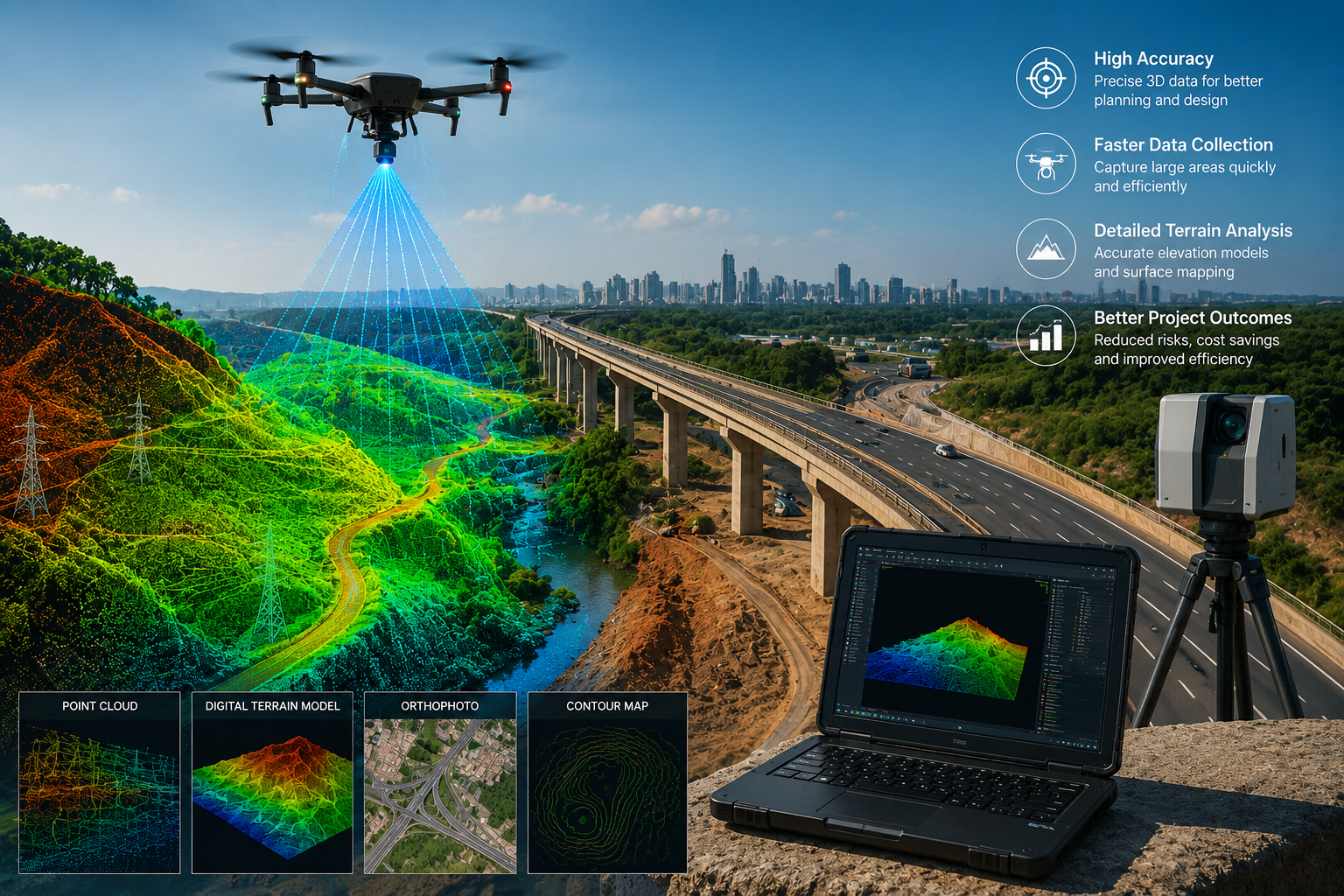
LiDAR stands for Light Detection and Ranging. It is a remote sensing technology that uses laser pulses to measure distances between the sensor and the Earth's surface. These measurements generate highly accurate 3D point cloud data, which can be used to create:
- Digital Terrain Models (DTM)
- Digital Surface Models (DSM)
- Contour maps
- Orthophotos
- Elevation models
- Corridor mapping data
LiDAR mapping is commonly carried out using drones, aircraft, or mobile survey systems depending on project requirements.
For infrastructure projects in India, LiDAR surveys are widely used because they deliver precise spatial data even in challenging terrain conditions.
High Accuracy for Large-Scale Projects
One of the main reasons LiDAR mapping is essential for infrastructure projects is its exceptional accuracy.
Traditional survey methods can be time-consuming and difficult when covering highways, railway corridors, forests, mountains, or densely populated urban areas. LiDAR technology captures millions of data points within a short period, allowing engineers to analyse terrain conditions with high precision.
This accuracy is critical for:
- Road alignment planning
- Railway route surveys
- Bridge construction
- Canal and pipeline projects
- Smart city development
- Utility infrastructure planning
Experienced geospatial companies such as MAPe IT Solutions use advanced LiDAR processing workflows to ensure reliable deliverables for infrastructure consultants and engineering firms.
Faster Data Collection and Reduced Project Time
Infrastructure projects often work under strict deadlines. Delays in surveying and mapping can impact the entire construction schedule.
LiDAR mapping significantly reduces field survey time by capturing large areas quickly and efficiently. Drone-based LiDAR surveys, for example, can cover extensive project corridors in a fraction of the time required by conventional methods.
Benefits include:
- Faster project planning
- Reduced manpower requirements
- Quicker decision-making
- Improved workflow efficiency
- Reduced site revisits
For large infrastructure developments in Chennai and across India, faster geospatial data collection directly contributes to cost savings and improved project execution.
Reliable Terrain Analysis
Accurate terrain information is essential before starting any infrastructure project.
LiDAR mapping provides detailed elevation data that helps engineers understand:
- Ground slope
- Surface variations
- Vegetation cover
- Drainage patterns
- Flood-prone areas
- Existing structures
This information supports better engineering design and minimises construction risks.
LiDAR technology is particularly valuable in regions with dense vegetation because laser pulses can penetrate through gaps in the canopy to capture ground elevation data accurately.
This makes LiDAR Survey Services in India highly useful for highway, railway, mining, and transmission line projects.
Looking for reliable LiDAR Survey Services in India?
MAPe IT Solutions delivers high-accuracy LiDAR mapping, drone surveys, GIS solutions, and geospatial data processing services for engineering and construction industries across India.
Improved Planning and Design
Infrastructure planning depends heavily on accurate base maps and terrain models.
LiDAR mapping supports engineers, architects, and planners by providing detailed spatial information for:
- Alignment design
- Earthwork calculations
- Utility planning
- Structural analysis
- Drainage design
- Environmental assessments
Accurate LiDAR data helps reduce design errors and supports better coordination between project stakeholders.
Many engineering consultants also integrate LiDAR data with BIM workflows and CAD drafting services to improve overall project management.
This creates natural opportunities for organisations to combine LiDAR mapping with:
These integrated geospatial solutions improve infrastructure planning efficiency and long-term asset management.
Enhanced Safety in Survey Operations
Certain infrastructure project locations can be dangerous or difficult to access.
Examples include:
- Mountain terrain
- Highways with heavy traffic
- Mining zones
- River crossings
- Dense forests
LiDAR mapping reduces the need for survey teams to physically enter hazardous areas. Drone-based LiDAR systems can safely capture accurate data remotely.
This improves:
- Worker safety
- Survey efficiency
- Data reliability
- Operational productivity
As infrastructure projects become more complex, safe and efficient survey methods are becoming increasingly important.
Better Asset Management and Future Maintenance
LiDAR mapping is not only useful during construction but also valuable for long-term infrastructure management.
The detailed 3D datasets generated through LiDAR surveys can support:
- Asset monitoring
- Road maintenance planning
- Utility inspections
- Structural assessments
- Expansion projects
Government agencies and infrastructure developers increasingly use LiDAR data to create digital infrastructure records for future planning and maintenance activities.
This long-term usability makes LiDAR one of the most cost-effective geospatial technologies available today.
Why Experience and Expertise Matter in LiDAR Projects
LiDAR mapping requires specialised technical expertise, advanced processing capabilities, and industry knowledge.
Accurate deliverables depend on:
- Proper mission planning
- Sensor calibration
- Data classification
- Point cloud processing
- Quality control workflows
Working with an experienced geospatial company ensures that infrastructure projects receive dependable and industry-standard outputs.
MAPe IT Solutions combines technical expertise, industry experience, and advanced geospatial technologies to support infrastructure and engineering projects across India. The company provides customised mapping solutions designed to meet the accuracy and scalability requirements of modern infrastructure development.
LiDAR mapping has become an essential technology for infrastructure projects because it delivers highly accurate spatial data, faster survey execution, improved terrain analysis, and safer field operations.
As infrastructure development continues to expand across India, organisations require reliable geospatial solutions to improve planning, reduce project risks, and optimise construction workflows.
From highways and railways to smart cities and utility networks, LiDAR technology plays a critical role in modern engineering and infrastructure management.
Need professional LiDAR Survey Services in Chennai or anywhere in India?
Contact MAPe IT Solutions for accurate LiDAR mapping, drone surveys, GIS solutions, CAD drafting, and infrastructure geospatial services tailored to your project requirements.
Frequently Asked Questions
1. What is LiDAR mapping used for in infrastructure projects?
LiDAR mapping is used for terrain analysis, corridor mapping, elevation modelling, road planning, railway surveys, utility mapping, and smart city development projects.
2. Why is LiDAR better than traditional surveying methods?
LiDAR mapping captures highly accurate data faster than conventional survey methods and can efficiently survey large or difficult terrains with reduced manpower.
3. Which industries use LiDAR Survey Services in India?
Industries including construction, mining, railways, highways, utilities, urban planning, and environmental management commonly use LiDAR surveys.
4. Can LiDAR surveys be performed using drones?
Yes. Drone-based LiDAR surveys are widely used for infrastructure and engineering projects because they provide faster and safer data collection.
5. Why choose MAPe IT Solutions for LiDAR mapping?
MAPe IT Solutions provides professional LiDAR Survey Services in India with expertise in geospatial technologies, infrastructure mapping, drone surveys, GIS solutions, and accurate data processing workflows.