We Serve For Various Industries:
In addition to drone mapping and survey services, we also offer:
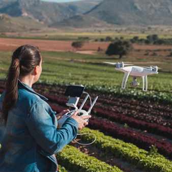
Drone surveying services have transformed how civil and earthworks based businesses work. If your business requires drone surveying or mapping services in Surat, contact the reliable GIS Mapping service provider in India - MAPe IT Solutions. We are a Geospatial Mapping Company in India, offering drone mapping and survey services in Surat. We use state-of-the-art drones like Ninja UAV and DJI 2S to collect accurate data for a variety of purposes, including land surveying, infrastructure development, agriculture, environmental monitoring, and construction planning. Being the No.1 GIS Mapping company in India, we deliver 100% customer satisfaction through our transparent service.
With successful services and years of expertise in drone surveying, we can create accurate maps of land, including its boundaries, features, and elevation. This information can be used for a variety of purposes, such as property development, construction, and environmental monitoring.
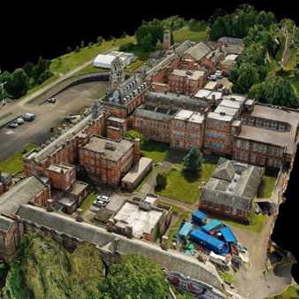
Do you want to capture any inaccessible terrain or dangerous environment? Our drone inspection service can help you out. As your trusted partner for drone inspection in Surat,we offer expert advice, customised solutions, and reliable service. Our drones can be used to inspect bridges, buildings, power lines, and other infrastructure for damage or defects. Doing so, helps to prevent accidents and ensure the safety of people and property.
In addition to drone mapping and survey services, we also offer:
● We are GIS Mapping and drone surveying experts, helping businesses with advanced mapping solutions.
● We have a team of experienced professionals with extensive knowledge of drone technology, aerial surveying, and mapping techniques.
● We understand that each client is different and we offer tailored solutions to meet your specific requirements.
● Our drones are equipped with advanced sensors that ensure precise data capture.
● We use cutting-edge technology to complete projects quickly and efficiently.
● Our drones are a cost-effective alternative to traditional surveying methods.
● Our drone surveying in Surat has a proven track record of success in a variety of industries.
Contact us today to discuss your drone mapping and survey needs in Surat. We would be happy to help you get started with your project. We also offer our drone mapping services in Bangalore, Kerala, New Delhi, Hyderabad, Mumbai, Kolkata, Pune, Ahmedabad, and Chennai. Call us at 044-29520530 | +919443338087 today.